Subscribe to our mailing list to receive news releases and other materials related to Tisdale Clean Energy Corp. Your email will never be shared or sold and you can opt out at any time.
of moderately dipping, multiple-stacked uranium and thorium mineralized
horizons down to 175 metres that is open to the southwest and east-northeast as
well as at depth.
*The historical resource is described in a technical report on the Falcon Point uranium project, Northern Saskatchewan, dated March 20, 2015, and filed on SEDAR by Skyharbour Resources Ltd. Tisdale is not treating the resource as current and has not completed sufficient work to classify the resource as a current mineral resource. While Tisdale is not treating the historical resource as current, it does believe the work conducted is reliable and the information may be of assistance to readers.
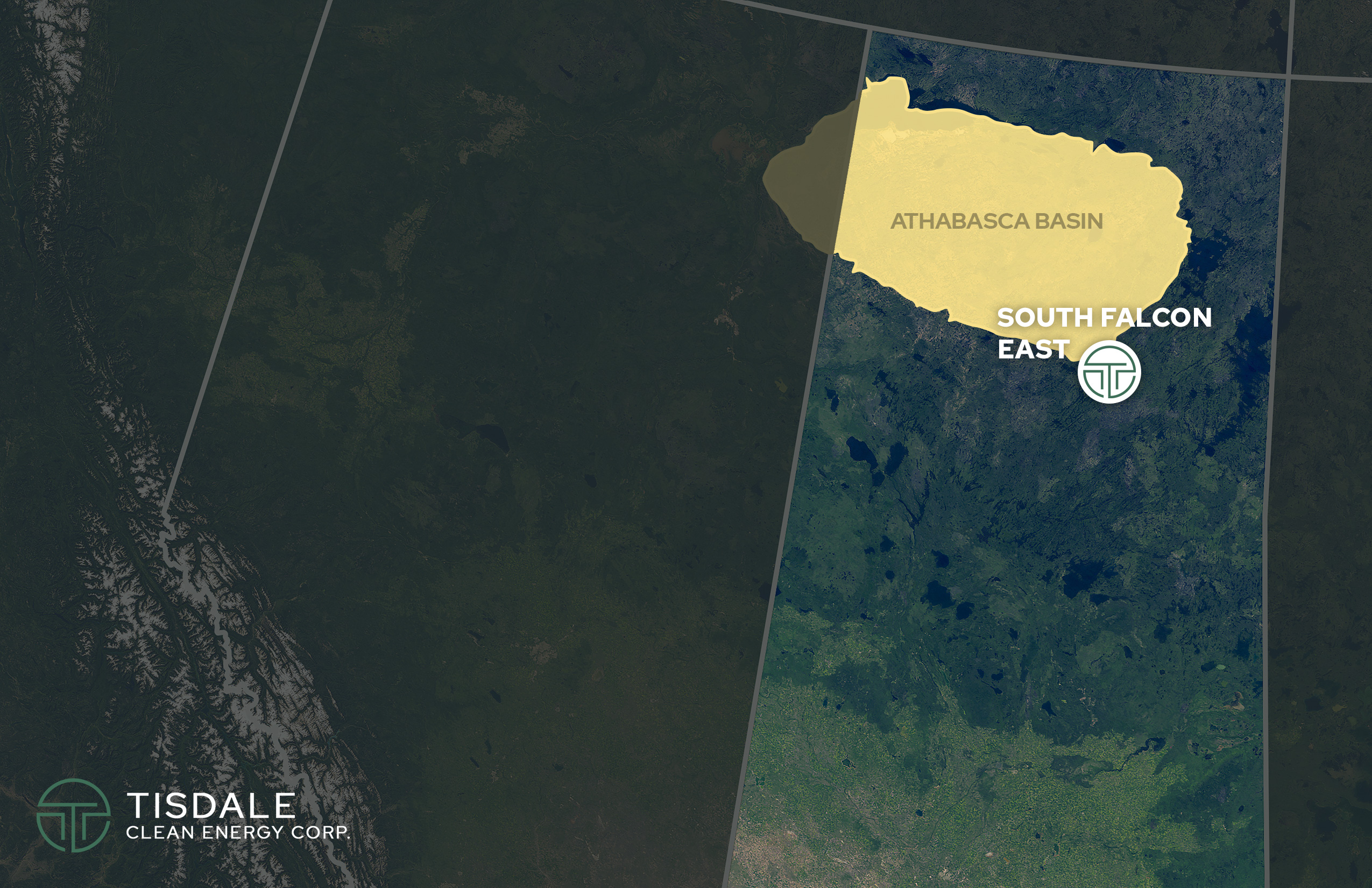
The South Falcon East property covers approx. 12,234 ha and lies 18 kilometers outside the southeast portion of the Athabasca Basin, 55 kilometers east of the Key Lake Mine. The project area is in close proximity to two all-weather northern highways and grid power.
In the years 2008 through 2011 outcrop grab samples from South Falcon East returned from 0.038% to 0.453% U3O8 and drill core samples returned mineralized sections with values from 0.012% to 0.552% U3O8.
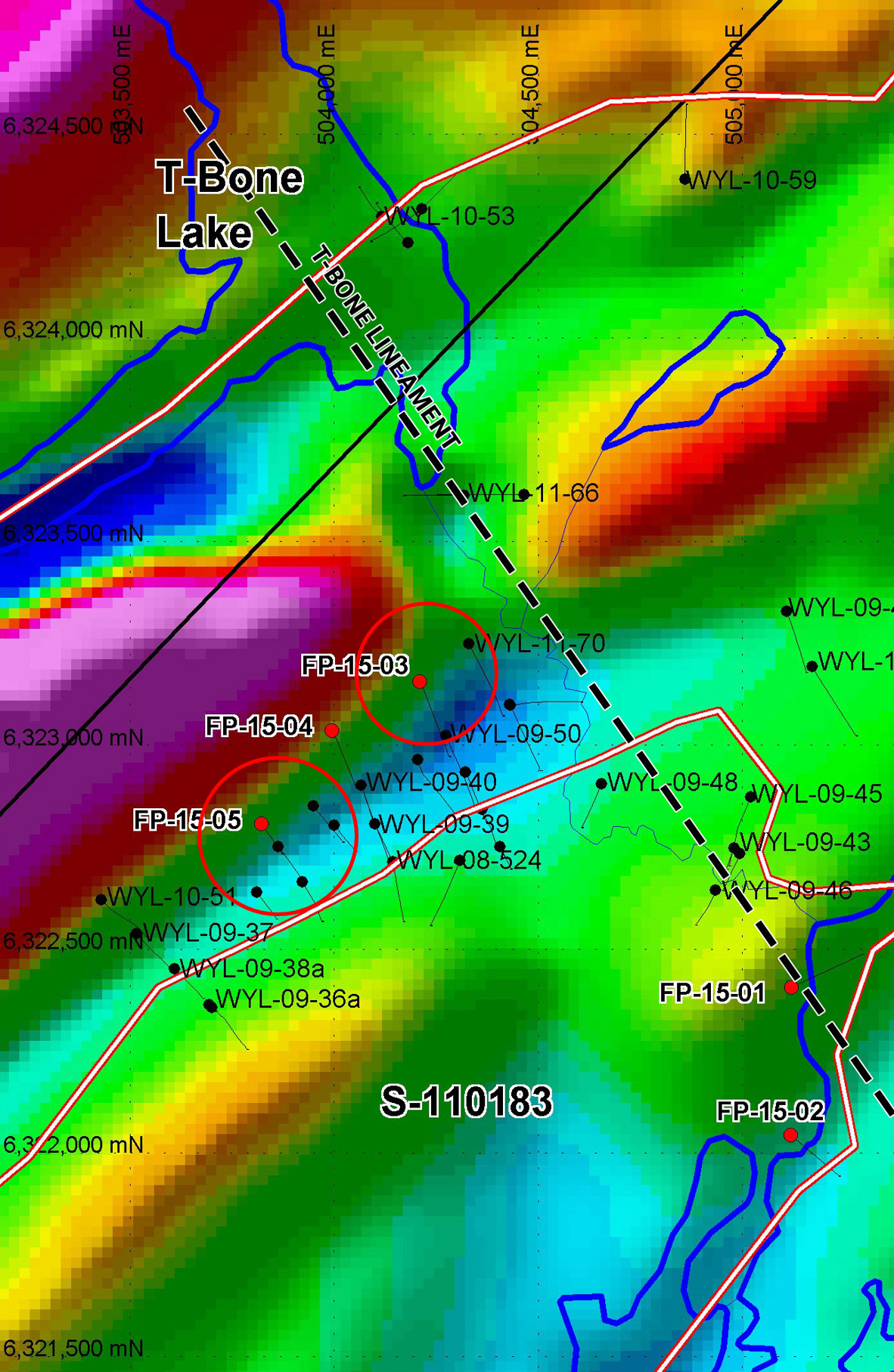
In 2015 Skyharbour Resources drilled five (5) holes (1,278m) testing various targets. Multiple intervals of uranium mineralization were intersected in several drill holes during the winter program. This mineralization is accompanied by local thorium enrichment and anomalous levels of pathfinder elements such as copper, nickel, vanadium and lead.
Hole FP-15-03 returned a 3-meter interval of .082% U308, including 2-meters of .10% U308 (at 295-meter depth).
The best intersections occur in drill hole FP-15-05 which was drilled within the main mineralized Fraser Lakes conductive corridor.
Hole FP-15-05 returned multiple mineralized intervals over a 14 meter down hole length, including 6 meters of .10% U308 (including a 2-meter intercept of 0.165% U3O8 (at 135-meter depth), and 2.5-meter interval of 0.172% U3O8 (at 145-meter depth).
Source: SKYHARBOUR RESOURCES LTD. FALCON POINT PROJECT 2015 WINTER DIAMOND DRILLING PROGRAM, Dave Billard, P.Geo. Cypress Geoservices Ltd.
Historical exploration at the South Falcon East Project identified an area of U-Th-REE mineralization at the Fraser Lakes Zone B deposit over an area comprising 1.5 km by 0.5 km along an antiformal fold nose cut by an east-west dextral ductile-brittle cross-structure adjacent to a 65 km long EM conductor. The near-surface Fraser Lakes Zone B deposit consists of a historical NI 43-101 inferred resource totaling 7.0 million pounds of U3O8 at 0.03% and 5.3 million pounds of ThO2 at 0.023% within 10,354,926 tonnes using a cut-off grade of 0.01% U3O8. The independent NI 43-101 technical report by GeoVector Management Inc. supporting this historic mineral resource estimate was filed on SEDAR on March 20, 2015, by Skyharbour.
Independent qualified person, Dr. Allan Armitage, P.Geo., is responsible for the contents of the technical report and comments related to the resource estimate and its parameters.
*The historical resource is described in a technical report on the Falcon Point uranium project, Northern Saskatchewan, dated March 20, 2015, and filed on SEDAR by Skyharbour Resources Ltd. Tisdale is not treating the resource as current and has not completed sufficient work to classify the resource as a current mineral resource. While Tisdale is not treating the historical resource as current, it does believe the work conducted is reliable and the information may be of assistance to readers.
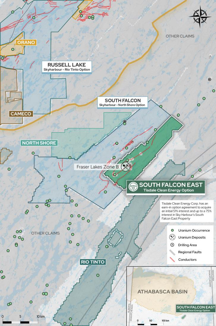
Discovered in 2008, Zone B is located within the broader 6-kilometre by 7-kilometre Fraser Lakes target area where multiple mineralized zones have been discovered along a 65-kilometre-long, folded EM conductor system comprised of Wollaston Group graphitic pelitic gneisses and uraniferous granitic pegmatites.
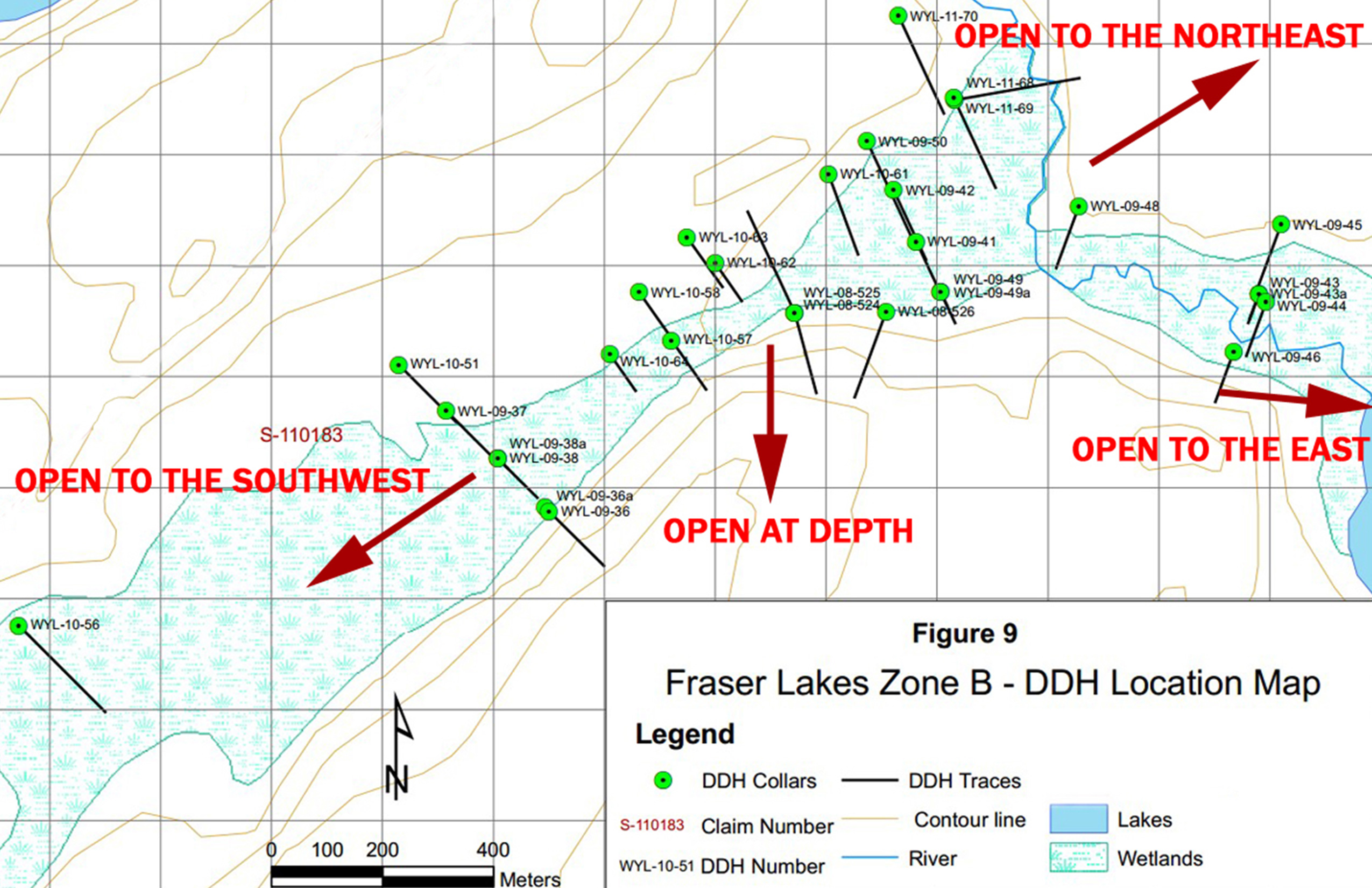
Diamond drilling consisting of 25 holes totaling 4,603 metres has defined a zone of moderately dipping, multiple-stacked uranium and thorium mineralized horizons down to 175 metres that is open to the southwest and east-northeast as well as at depth. Uranium and thorium mineralization is accompanied by highly anomalous concentrations of base metals, rare earth elements and other pathfinder elements. The style of uranium mineralization associated with intrusive rocks is commonly referred to as “Rössing type” mineralization named after the largest, longest running open pit uranium mine in the world, the Rössing Mine operated by Rio Tinto in Namibia.
JNR Resources Inc., a company acquired by Denison in 2013, announced an initial historic mineral resource estimate in 2012 (Refiled in March of 2015 by Skyharbour Resources) for the Fraser Lakes Zone B of 6,960,681 pounds U3O8 inferred at an average grade of 0.03% U3O8 and 5,339,219 pounds ThO2 inferred at an average grade of 0.023% ThO2 within 10,354,926 tonnes using a cutoff grade of 0.01% U3O8. The independent NI 43-101 technical report supporting this historical mineral resource estimate was filed on SEDAR on September 26, 2012 by JNR Resources. Independent qualified persons, Dr. Allan Armitage, P.Geo., and Alan Sexton, M.Sc., P.Geo., of GeoVector Management Inc., are responsible for the contents of the technical report and comments related to the historical resource estimate and its parameters.
Cut-off Grade | Tonnes | U3O8 | La2O3 | Ce2O3 | Yb2O3 | Y2O3 | |||||
Grade (%) | Lbs | Grade (%) | Lbs | Grade (%) | Lbs | Grade (%) | Lbs | Grade (%) | Lbs | ||
0.01% | 10,354,926 | 0.030 | 6,960,681 | 0.003 | 681,325 | 0.006 | 895,077 | 0.001 | 304,762 | 0.007 | 1,619,017 |
0.02% | 7,247,689 | 0.037 | 5,948,018 | 0.003 | 478,275 | 0.006 | 749,829 | 0.002 | 248,278 | 0.008 | 1,295,283 |
0.03% | 4,248,266 | 0.046 | 4,275,145 | 0.003 | 281,423 | 0.006 | 535,677 | 0.002 | 165,658 | 0.009 | 824,093 |
0.04% | 2,212,182 | 0.056 | 2,744,506 | 0.003 | 147,628 | 0.006 | 323,996 | 0.002 | 107,082 | 0.011 | 512,639 |